


Directories, maps under construction
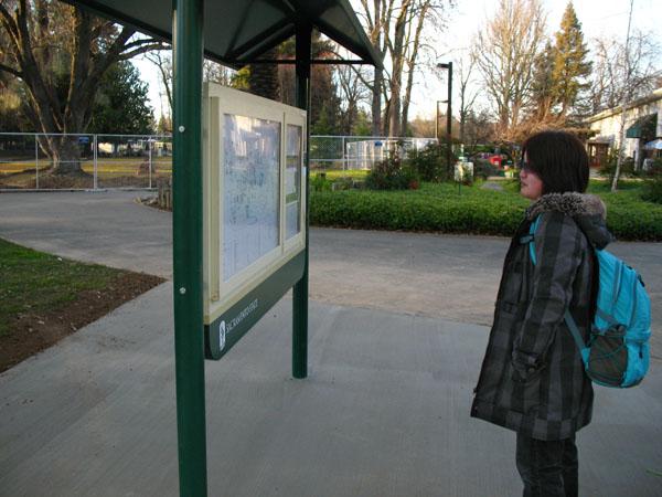
Junior engineering student Haruna Kochiyama poses in front of Riverfront Center by one of the new campus directories.:
February 14, 2008
Have you ever been somewhere and felt lost?
For new students and visitors to Sacramento State, finding a particular building may produce the same feeling. To alleviate this, the Facilities Services crew recently removed some of the kiosks and replaced them with campus directories and maps, which are strategically placed throughout the grounds.
There will be a total of eight large and 10 smaller directories with maps dispersed throughout Sac State that are currently under construction. The directories will consist of an alphabetical listing of the names of the campus buildings, their abbreviations and the grid locations on the campus maps.
There are four phases of the Way Finding Project. The directories and maps are the last phase of the project, said Todd McComb, drafting technician with Project Design and Development for Facilities Services.
The maps are printed on card stock and can be easily changed as new buildings are constructed, such as the apartment-style residential hall and the Recreation, Wellness and Events Center.
The total cost of the 18 directories and maps was not disclosed because many people working on the project are not privy to that information and the administrator in charge, Ron Richardson, associate vice president for Facilities Services, was attending a Los Angeles conference and could not be reached for comment.
Senior history major Nicholas Moore said the directory printing is too small for the visually impaired and needs to include Braille. Because the larger directories and maps are too high for wheelchair-bound individuals, they are not in compliance with the Americans with Disabilities Law, he said.
There used to be four original directories and maps on campus, one at the north, south, west and east ends of the campus. However, people complained that they were still confused when navigating their way through Sac State. The university then consulted other colleges to determine what they did. Finally, Facilities Services proceeded with its current project, as it’s the standard of the Chancellor’s Office, used in the master plan, and is how all the utility maps and campus aerial maps are done.
“We’re just trying to build consistency,” McComb said.
In addition to the directories and maps project, there are other ways to become familiar with Sac State.
During the day, two staffed information booths give campus directions. The booths are located just past the J Street entrance and on State University Drive South, behind the Alumni Center. On campus, there is an information window in Sacramento Hall and an information desk in the University Union. The latter opens at 6:30 a.m. on weekdays and closes at 9 p.m. or later, usually at midnight on Sundays through Thursdays.
The Union’s information desk is used as a resource for directions on campus. The employee will show a person the laminated, colored campus map and will then give a photocopy of it with a highlighted pathway to walk.
“No one is going to have as much extensive information as we are,” undeclared sophomore Rene Nevarez, who works as an attendant at the Union’s information desk said. “We’re the only place on campus; if we don’t know the answer, we’ll find out for you too and won’t just send you away.”
Phase I of the project was the curved “California State University, Sacramento” entrance signs. Phase II was the vehicular signs on the State University Drive perimeter road and Phase III was the exterior building signs with the arrowheads to point someone in the correct direction.
Leonard Low can be reached at [email protected].