


Methods to help prevent natural disasters made 3-D during event
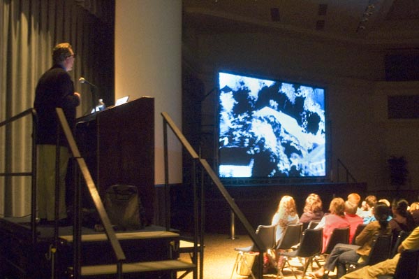
Dr. Gerald Bawden, U.S. geological survey scientist, presented a lecture using a high-tech, three-dimensional glasses system that is said to help visualize real-world disasters.:
March 13, 2008
More than 300 people gathered to hear geologist and Sacramento State adjunct professor Gerald Bawden present the newest form of 3-D technology that is helping scientists study natural disasters and prevention methods.
Through the merging of two technologies, laser and virtual reality, Bawden is able to scan the earth using instruments with ultra-high resolution 3-D imagery.
These instruments are set up to scan the surrounding landscape inch by inch and recreate the same location on-screen in the form of little dots. It takes millions of these dots to recreate the exact image because of the intricate terrain.
This high resolution 3-D technology catches everything from a large boulder to a single blade of grass and makes it very useful for scientists to detect changes that result from natural disasters.
Scientists track the changes by scanning the same location over a period of time and comparing each image. The changes are colorized to represent each time the data was collected and placed over the original scanned image. This allowed the audience to see how much the earth shifted throughout the time frame in which the data was collected.
Audience members wore 3-D glasses throughout the presentation that allowed them to see how this technology tracks the changes in the ground through time. The glasses made it possible to see the scanned landscape in the form of millions of dots and showed the intricacies of the land in a 3-D format.
In his presentation, Bawden demonstrated how the combined technology tracks changes in the earth from five specific types of natural disasters: landslides, debris flows, earthquakes, snow-melt and dam failures. Bawden noted that although snow-melt is not a natural disaster, it does impact the earth as the excess water flows into meadows and creates potential problems.
Bawden and a team of scientists from the United States Geological Survey studied the to the audience how much the terrain had moved as a result.
“We are able to create an incredible archive of what this landslide looks like,” Bawden said in his presentation. Bawden said the new technology will help them learn exactly what happened during the Laguna Beach landslide based on the data, which also allows them to pinpoint weak spots in the land.
Bawden also used the 3-D technology to illustrate the changes in the Ka Loko reservoir in Kilauea, Hawaii.
On March 14, 2006, a dam breach in the Ka Loko reservoir caused millions of gallons of water to come rushing out directly onto a village below, killing seven people. Bawden and the United States Geological Survey scientists were able to gather useful information about the breach, but the exact reason for the dam failure is still unknown.
“We can’t tell if the dam over-topped or failed. We ended up having a complex breach pattern,” Bawden said.
Using the technology to scan the landscape, they were able to learn how much water came rushing out and through that, they were able to estimate the force of power and impact that the water created upon the breach.
Through the data collected, they learned that the reservoir had drained about 90 percent of its water before there was a pause in the outpour.
During this initial flow, they were able to discern that 341 million gallons of water rushed out of the reservoir. After the first pause, another 34 million gallons of water came out, bringing the total to an estimated 375 million gallons of water that rushed out of the reservoir due to the breach.
Knowing the amount of water that came rushing out of the dam helps scientists understand the force of impact it will have on the landscape and may prevent further disasters in other locations.
Bawden wrapped up his presentation by showing the audience how United States Geological Survey scientists were able to see the changes in the earth due to debris flows and also through the amount of water that results from snow-melts.
Debris flows, composed of rocks, debris and soil, are caused by storms and come rushing down from hillsides in the form of a landslide. This landslide of debris inundates neighborhoods below and causes damage to structures, roads, utilities and homes. Bawden and United States Geological Survey scientists use the 3-D technology to study areas susceptible to debris flows.
Bawden also showed how the 3-D technology allows scientists to measure the volume of water that a snow-melt will generate and how this addition of water will affect the surrounding meadows it will pour into.
The lecture presented by Bawden, who helps guide research on campus, drew a large audience that filled the University Union Ballroom.
The disaster-vision lecture was the third in a series of four and is presented by Sac State’s Science, Technology, Engineering and Mathematics program.
The technology introduced by Bawden provides useful information to Sac State students who are interested in doing this kind of fieldwork and pursuing geology as a career.
Many students came to watch the disaster-vision lecture, including Sierra Community College student Amy Bower who learned of the event through a friend. Although she is a psychology major, Bower came out to see the lecture because she thought it would be appealing.
“I was interested in a 3-D lecture and what he had to say about natural occurrence,” Bower said. “It was impressive as far as what technology they used.”
Robin Wham, who is a teacher’s assistant in the geology department at Sac State, also came out to see the lecture and support the Science, Technology, Engineering and Mathematics program.
“I thought the imagery and technology are cutting edge and there is a lot to be seen in the future using this technology,” Wham said. “(Bawden) took something that was extraordinarily complex and presented it in a way for us to understand.”
There was only one thing that Wham would like to see in future lectures by the United States Geological Survey.”I’d like to see (the technology) used in a volcano,” Wham said.
When asked, Bawden said he planned to study the Mauna Loa volcanic activity when he was in Hawaii gathering data on the Ka Loko reservoir breach, but could not do so due to instrument failure. Bawden said he will return to Hawaii in the near future to study the active volcano.
Bawden hopes his lecture made an impact on the audience and said there is one thing he hopes people will remember from the disaster-vision lecture.
“We can use new technology to medicate disasters and better understand how disasters take place to help minimize losses,” Bawden said.
For more information on the United States Geological Survey and the disaster-vision technology, Bawden can be reached at (916) 278-3131.
To learn more about the Science, Technology, Engineering and Mathematics program, visit www.csus.edu/stem.
Isela Reyes can be reached at [email protected].